Pages

Tuesday, June 30

Sky High & Down to Earth

Our "end of the road" journey to McCarthy (pop 200 - year round 25) and Kennecott (even smaller) ends at the banks of the Nizma River. Then, two footbridges and a half mile hike brings you to McCarthy - residents can pay $300 a year to use a privately owned vehicle bridge, and a shuttle service does run from the footbridge to town and on to Kennecott. Our first stop was the town's history museum, then The Potato for a snack (galic french fries), then a walk around town - where we discovered McCarthy Air, and schedule a "flightseeing" tour for later in the day. With a couple hours to kill before our flight we stopped in at the New Golden Saloon for a beer - spent the time talking with three Swiss travelers.

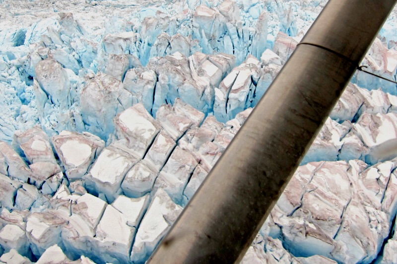
Then it's off to the airport, where we meet our pilot - Gary Green has been flying in Alaska for 45 years, owns his own plane and has a lot of experience! Off we go for a flight unlike any I've experienced (remember I'm a pilot) as we cruise over glaciers, alongside mountains (25 feet away from the planes wingtip), looking at wildlife, rivers, lakes, and vast snow and icefields. Spectacular!


The next day we keep our feet firmly on the ground as we walked around the Kennecott Mill Town (now a National Historic Landmark administered by the NPS) - not as eye popping as our glacier flight, but pretty impressive. The first ore train departed the mill in 1911 and in the 27 years of operation Kennecott produced 4.625 million tons of ore averaging 13 per cent copper valued at roughly $207,000,000. The last train left Kennecott on November 10, 1938, leaving it a ghost town. Today fewer than 25 people reside year round.

Kennecott Mill from the air
The Mill
Power Plant


Monday, June 29

Getting There

Tonight we are in McCarthy, a place Alaskans call an "end of the road" place - actually, their are numerous "end of the road" places in Alaska and I'm pretty sure this won't be our last. To get to these places usually means a gravel/dirt road, some dust and/or mud, and lots of bumps. The pluses - no crowds, great scenery, and a guaranteed surprise or two.

The Kuskulana River Bridge
It's single lane is 238 feet above the river
Fuel Stop - we've got to have our ice cream

Gilahina Trestle - no longer in use, was built in 1911 in eight days


After 60 miles the end of the road and surprise - you park and walk the last half mile to town.


Turn in tomorrow to see why we drove to the end of this particular road.


Sunday, June 28

Wilderness Roads

We've finished our Nabesna Highway adventure in Wrangell-St. Elias and are now 100 miles south at Chitina getting ready to explore the McCarthy Road tomorrow - destination the abandoned Kennecott Copper Mine, which is now a National Historic Landmark. This 60 mile gravel road was once a railroad line (constructed in 1909 to support the mine) and vehicles still suffer occasional flat tires from a leftover railroad spike. I've been told to just take it slow and easy and watch for the idiots that don't.

Copper sign a the Visitor Center
Fish Wheel on display
Just a roadside view


Saturday, June 27

Wilderness Alaska

We plan to spend the next several days in and around America's Largest National Park - Wrangell-St. Elias. It's hard to grasp the shear size of this place,13.2 million acres (6 Yellowstones). It includes 9 of the 16 highest peaks in the United States, an active volcano, the largest ice field in North America, and - the list goes on and on. Created in 1980 it is largely undeveloped with only two gravel access roads (we will drive both) and very limited facilities.

Our wilderness experience begins after a 60 mile drive on the Glenn Highway with a stop at the Slana Ranger Station. We check road conditions for the 42 mile (gravel road) drive into the park, and get campsite and hiking information. While in the Ranger Station a local fisherman stops in to update his permit - we start talking and we learn he is a "subsistence" fisherman (hunter, trapper, etc) that lives off the land (and is entitled to do so by Alaskan law). After a little chat he asks if we like salmon - well yah, so off we go to see his fish wheel in action. We arrive at his "wheel" and the fish are rolling in - he can catch 500 fish each season for his family, and others can use his wheel with his permission to catch their limit - it varies with your native status. Outsiders, like us, can't use a wheel - but he can give us some of his allotment. Guess what we had for dinner tonight?

Wheel goes round, powered by the river current
River to plate in less than five hours


After talking and fishing for an hour or so we head into the park. Fantastic country - very hard to describe (or take pictures of) but our drive on the Nabesna Road was a true wilderness experience - and not without its challenges. When we got to our campsite it was raining and mountain nearby was covered by new snow - the locals call this type of late/early snow "termination dust" - It signals the end of a season.

2nd of 6 water crossings

Tougher than it looks - took two tries at this one
At the end of the road


Little lake at our campground


Friday, June 26

Chicken Alaska

Hope everyone is ready for some excitement. Our first stop (after our return to Alaska) is the metropolis of Chicken - which makes Hyder look gigantic. Chicken is an old mining town that has found a way to hang on. You can vist the Chicken Cafe, pan for gold, and if you pass this way in August attend ChickenStock (a music festival).


It's all about the chicken in Chicken. The highlight being this big sign that shows the distance "as the chicken flies" to various cities around the world. You need to look closely at the sign - several readers will recognize a name or two.


Just a bonus chicken.


Thursday, June 25

Finally, Alaska!

Today we left Dawson on the Top Of The World highway - 160 miles of mostly gravel road - with Alaska finally within reach. After 9432 miles and 81 days we headed toward the northernmost border crossing in North America - for comparison, a direct route from Bardstown, Kentucky, would have been under 4000 miles.

First step, get across the Yukon River. Because the van is so small we were able to jump ahead of all the big rigs in line. Quick 10 minutes and we were on the other side.


Next challenge, the Top Of The World highway. A little rough and muddy - but hey, traffic was very light. This road has some great views, but with the smoke from several big wildfires we couldn't see much. The border crossing was supper easy - and wer're back (remember our 19 hours in Hyder) in Alaska.


This not so modern road grader at the entrance to our BLM Campground.